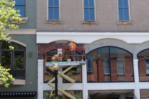
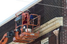
 With the brickwork of the Urban Outfitters building across the street reflected in glass, workers applied brick to the facade of 7 Broad Street in Red Bank Tuesday. And over on Wallace Street, a mason repointed existing brick above Rocky’s Barber Shop.
The Greater Red Bank Green, along with the entire eastern and central parts of the United States, is expected to feel like a brick oven in coming days. According to the National Weather Service, dangerously hot conditions will arrive Wednesday, with “feels like” temperatures getting as high as 106 degrees. Excessive heat will may return Friday and persist through the weekend. Read the NWS heat advisory for more details.
Wednesday night, there’s also a chance of thunderstorms accompanied by high winds, lightning and flash flooding.
Check out the extended forecast below. (Photos by John T. Ward. Click to enlarge.)
Wednesday
A chance of showers and thunderstorms, mainly after 3pm. Some of the storms could produce gusty winds, heavy rain, and frequent lightning. Partly sunny, with a high near 93. Heat index values as high as 103. Light southwest wind increasing to 5 to 10 mph in the morning. Chance of precipitation is 30%. New rainfall amounts of less than a tenth of an inch, except higher amounts possible in thunderstorms.
Wednesday night
Showers and thunderstorms likely before 8pm, then showers and possibly a thunderstorm between 8pm and 10pm, then showers and thunderstorms likely after 10pm. Some of the storms could produce gusty winds, heavy rain, and frequent lightning. Areas of fog after 2am. Low around 74. Southwest wind 3 to 7 mph. Chance of precipitation is 80%. New rainfall amounts between three quarters and one inch possible.
Thursday
A chance of showers and thunderstorms, then showers likely and possibly a thunderstorm after 2pm. Areas of fog before 8am. Otherwise, mostly cloudy, with a high near 85. Southwest wind around 5 mph becoming calm in the morning. Chance of precipitation is 60%. New rainfall amounts between a quarter and half of an inch possible.
Thursday night
Showers likely and possibly a thunderstorm before 8pm, then a chance of showers and thunderstorms between 8pm and 2am, then a slight chance of showers after 2am. Mostly cloudy, with a low around 73. Calm wind becoming east around 5 mph after midnight. Chance of precipitation is 60%. New rainfall amounts between a tenth and quarter of an inch, except higher amounts possible in thunderstorms.
Friday
Mostly sunny, with a high near 91. Calm wind becoming south 5 to 7 mph in the afternoon.
Friday night
Partly cloudy, with a low around 77.
Saturday
Sunny and hot, with a high near 97.
Saturday night
Mostly clear, with a low around 78.
Sunday
Mostly sunny, with a high near 93.
Sunday night
A chance of showers and thunderstorms between 8pm and 2am. Partly cloudy, with a low around 75. Chance of precipitation is 30%.
Monday
A chance of showers and thunderstorms. Partly sunny, with a high near 89. Chance of precipitation is 40%.
Monday night
A chance of showers and thunderstorms. Mostly cloudy, with a low around 71. Chance of precipitation is 30%.
Tuesday
Partly sunny, with a high near 86.