 A winter storm that’s expected to begin Monday and continue overnight could have modest effect on the Greater Red Bank Green, according to the National Weather Service.
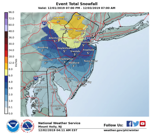
Expect morning rain turning to sleet in the afternoon, with snow mixing in starting around 3 p.m. Overnight, the storm is expected to leave between one to four inches locally and end around 4 a.m. Tuesday.
Areas to the immediate west and north, however, will see heavier accumulations, with possible impacts on transportation.
Check out the extended forecast below. (NWS image. Click to enlarge.)
Monday
Rain before noon, then rain and sleet between noon and 3pm, then rain, snow, and sleet after 3pm. High near 39. North wind 15 to 17 mph. Chance of precipitation is 100%. New snow and sleet accumulation of less than one inch possible.
Monday Night
Rain and snow, becoming all snow after 8pm. Low around 31. Blustery, with a north wind 18 to 21 mph. Chance of precipitation is 90%. New snow accumulation of 1 to 3 inches possible.
Tuesday
Mostly cloudy, then gradually becoming sunny, with a high near 42. Northwest wind 15 to 17 mph.
Tuesday Night
Partly cloudy, with a low around 30. West wind 8 to 13 mph.
Wednesday
Mostly cloudy, with a high near 44.
Wednesday Night
Mostly cloudy, with a low around 31.
Thursday
Mostly sunny, with a high near 43. Breezy.
Thursday Night
Mostly clear, with a low around 30.
Friday
Partly sunny, with a high near 45.
Friday Night
Partly cloudy, with a low around 30.
Saturday
Sunny, with a high near 39.
Saturday Night
Mostly clear, with a low around 28.
Sunday
Partly sunny, with a high near 47.