


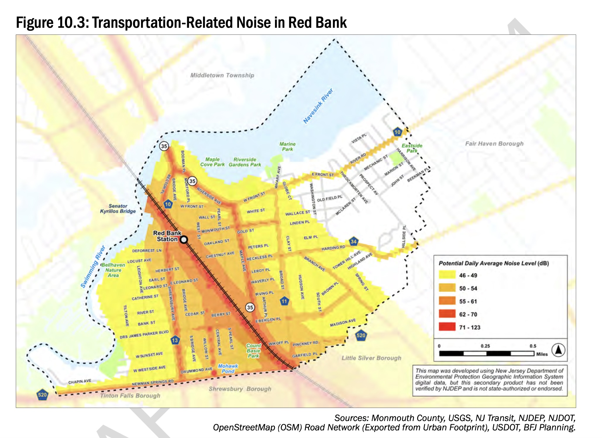
A map of Red Bank noise levels, sure to be pointed to by folks who want the town designated a quiet zone to get NJ Transit trains to use the horns less. Meanwhile, I can’t help but wonder if my street would be more red if they had taken readings when my neighbor with the monster truck was driving by. (Photo by Brian Donohue. Click to enlarge.)
By BRIAN DONOHUE
What’s the noisiest spot in Red Bank? What’s the hottest? Do you know where the water coming from your tap comes from?
Okay, fellow nerds, map lovers and geology geeks. We are here with the good news that at least some small portion of your property tax dollars have recently been spent building a series of really cool maps about our town.
They are part of the Borough of Red Bank Environmental Resource Inventory, a document that will certainly separate those of us who get excited about these things from the folks whose eyes will glaze over at this post because they lack intellectual curiosity.
The report will be the subject of a special meeting of the Red Bank Planning Board Wednesday at 7 pm at Borough Hall, during which the board will consider adding the inventory to the 2023 Master Plan. Read the report here if you are so inclined.
In the meantime, we read it so you don’t have to.
And there are all sorts of interesting tidbits of information in there that warrant more questions, such as why Red Bank’s recycling rates are consistently lower than the rest of Monmouth County; and what’s the status of the dozens of contaminated sites around town. We’re adding those to our long to-do list here at redbankgreen.
For now, though, here’s the few things that kept us from falling asleep while we sat on the couch with the 80 page report: The cool maps in the report explaining things like the different types of soil, noise levels, and more. Along with our enlightening commentary, of course.


I can’t wait for spring when I can turn to my wife and say, “I’m going out to dig in the Upper Stream Terrace Deposits.” Or my next conversation with my friend on Harrison Avenue when I can say, “Bruh, how’s it going over in the Upper Colluvium?”

My running route on freezing winter days has always shifted to the track at Count Basie Park, where the sun warms the artificial turf and track and the west wind is blocked by the bleachers. It feels like you can gain ten degrees on a January day. In summer, I avoid it like the plague for the same reasons. Now I see there’s some data behind my experience, as well as the hell experienced by football teams doing two-a-days on the turf in August. Actually, do they still do two-a-days? Hmm.

A good map showing all the pavement in town, fodder for the borough to set the goal of reducing the amount of purple in future maps and hopefully improving water quality in our runoff pollution-plagued Navesink River. The clam beds west of the Oceanic Bridge were closed in 2016 due to pathogen pollution and I’m dying for them to open back up someday because there’s got to be a gazillion of them waiting to get into my chowder pot. Less pavement, more clams, please.


While flooded basements during heavy rains is fairly common in Red Bank, it’s not nearly a common a problem as it is in other parts of the state, especially north Jersey where they may have better food (can we get a Korean chicken wing shop in this town, please?) but have to spend more time dealing with sump pumps. “The Freehold-Urban Land Complex consists of well drained sandy loam soils,” the report reads. “It is not rated as a hydric soil, and is not prone to ponding or flooding.” Sandy loam, our dry feet thank you!

It’s likely most people turn on their kitchen tap without ever thinking about where the water originates from.
Aside from a few months of the year when Red Bank’s water utility pulls from the Swimming River reservoir, the water we drink comes from four wells shown as purple dots on the map above.
A reminder that whatever you dump into that Freehold sandy loam might eventually come back through your pipes and into your coffee mug. (although at 700 feet deep the report notes the wells are not considered to be in danger of surface contamination)
redbankgreen editor Brian Donohue may be reached via email at [email protected] or by calling or texting 848-331-8331 or yelling his name loudly as he walks by. Do you value the news coverage provided by redbankgreen? Please become a financial supporter if you haven’t already. Click here to set your own level of monthly or annual contribution.


