 A day and a half of rain is expected to soak the Greater Red Bank Green starting Thursday morning, according to the National Weather Service.
As Tropical Storm Zeta charged northeast through Georgia early Thursday, remnants of the system were expected to bring sometimes-heavy rainfall to our area before tapering off Friday. With fallen leaves clogging sewers, that could create localized flooding and dangerous driving conditions, the NWS cautioned.
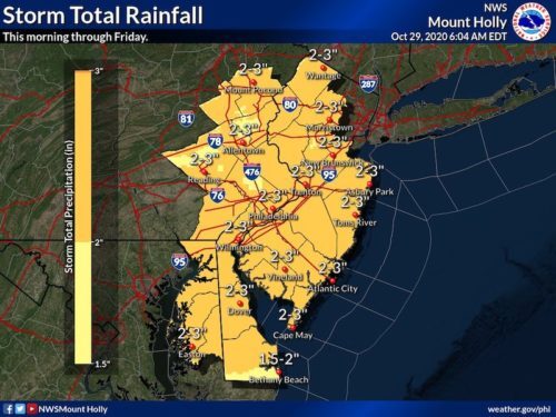
Check out the extended forecast below. (NWS image. Click to enlarge.)
Thursday
Rain, mainly after 7am. The rain could be heavy at times. Patchy fog before 9am. High near 57. East wind 5 to 15 mph. Chance of precipitation is 100%. New precipitation amounts between 1 and 2 inches possible.
Thursday Night
Rain. Low around 40. Breezy, with a northeast wind 15 to 20 mph, with gusts as high as 30 mph. Chance of precipitation is 100%. New precipitation amounts between a half and three quarters of an inch possible.
Friday
Rain, mainly before noon. High near 46. Breezy, with a north wind 15 to 20 mph, with gusts as high as 30 mph. Chance of precipitation is 80%. New precipitation amounts between a quarter and half of an inch possible.
Friday Night
Areas of frost after 2am. Otherwise, partly cloudy, with a low around 33. North wind around 10 mph.
Saturday
Areas of frost before 8am. Otherwise, sunny, with a high near 49.
Saturday Night
Partly cloudy, with a low around 41.
Sunday
A chance of showers. Partly sunny, with a high near 61. Chance of precipitation is 30%.
Sunday Night
A chance of rain before 2am. Partly cloudy, with a low around 35. Chance of precipitation is 30%.
Monday
Sunny, with a high near 47. Breezy.
Monday Night
Partly cloudy, with a low around 34.
Tuesday
Mostly sunny, with a high near 51.
Tuesday Night
Mostly clear, with a low around 39.
Wednesday
Sunny, with a high near 57.