 The ‘wolf moon‘ on the rise, as seen past a barn and trees at the historic Parker Homestead in Little Silver Thursday evening.
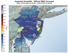
Early-risers on the Greater Red Bank Green awoke to howling winds and feels-like temperatures of just 3 degrees Fahrenheit Friday, according to the National Weather Service. The wind and bitter cold is expected to ease by Saturday, followed Sunday night by snow that could leave six inches over 24 hours.
See the extended forecast below. (Photo by John T. Ward. Click to enlarge.)
Friday
Sunny, with a high near 25. Wind chill values as low as -1. Windy, with a northwest wind 30 to 35 mph.
Friday Night
Mostly clear, with a low around 15. Wind chill values as low as zero. Windy, with a northwest wind 20 to 30 mph.
Saturday
Sunny, with a high near 30. Wind chill values as low as -1. Blustery, with a northwest wind 10 to 20 mph.
Saturday Night
Mostly clear, with a low around 17. Northwest wind 5 to 10 mph becoming light north after midnight.
Sunday
A slight chance of snow after 2pm. Mostly cloudy, with a high near 32. Calm wind becoming northeast around 5 mph. Chance of precipitation is 20%.
Sunday Night
Snow likely, mainly after 11pm. Cloudy, with a low around 28. Chance of precipitation is 70%.
Monday
Snow before 2pm, then rain and snow. High near 36. Breezy. Chance of precipitation is 90%.
Monday Night
Rain and snow, becoming all snow after 8pm. Low around 31. Blustery. Chance of precipitation is 90%.
Tuesday
Snow likely before 11am, then rain and snow likely. Cloudy, with a high near 36. Breezy. Chance of precipitation is 70%.
Tuesday Night
Snow likely, mainly before 8pm. Mostly cloudy, with a low around 26. Chance of precipitation is 60%.
Wednesday
A chance of snow. Mostly sunny, with a high near 37. Chance of precipitation is 30%.
Wednesday Night
Partly cloudy, with a low around 26.
Thursday
Mostly sunny, with a high near 42.