


![]() Strong winds are expected to push ‘feels-like’ temperatures below zero on the Greater Red Bank Green this weekend, according to the National Weather Service
Strong winds are expected to push ‘feels-like’ temperatures below zero on the Greater Red Bank Green this weekend, according to the National Weather Service
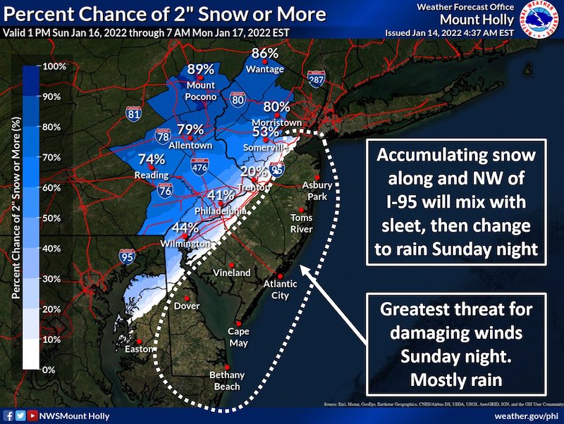
The region may be spared the snow accumulation expected elsewhere in New Jersey. But an “arctic plunge” beginning Friday night combined with potentially damaging winds could create wind-chills of minus 4 degrees Fahrenheit Saturday.
Uncertainty remains about an expected mix of rain and snow Sunday night, but we could see up to two inches of precipitation, the NWS said in the extended forecast below, issued early Friday morning. (NWS graphic. Click to enlarge.)
Friday
Cloudy, then gradually becoming mostly sunny, with a high near 42. Breezy, with a north wind 15 to 20 mph increasing to 20 to 25 mph in the afternoon. Winds could gust as high as 40 mph.
Friday Night
Mostly clear, with a low around 12. Wind chill values as low as -5. Blustery, with a north wind 20 to 25 mph.
Saturday
Increasing clouds, with a high near 23. Wind chill values as low as -4. North wind 10 to 15 mph.
Saturday Night
Mostly cloudy, then gradually becoming mostly clear, with a low around 11. Wind chill values as low as -1. North wind around 10 mph.
Sunday
A slight chance of snow after 4pm. Mostly sunny, with a high near 37. Northeast wind 5 to 15 mph becoming east in the afternoon. Chance of precipitation is 20%.
Sunday Night
Rain likely, possibly mixed with snow before 7pm, then rain. Low around 35. Windy. Chance of precipitation is 90%. New precipitation amounts between 1 and 2 inches possible.
Monday, Dr. Martin Luther King, Jr. Day
A chance of rain before 1pm. Mostly cloudy, with a high near 44. Chance of precipitation is 50%.
Monday Night
Mostly cloudy, with a low around 26. Breezy.
Tuesday
Sunny, with a high near 37.
Tuesday Night
Partly cloudy, with a low around 26.
Wednesday
Mostly cloudy, with a high near 43.
Wednesday Night
Mostly cloudy, with a low around 27.
Thursday
Partly sunny, with a high near 34.


