



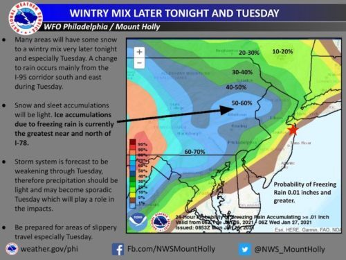
 A new workweek on the Greater Red Bank Green starts off with sunshine Monday. But we may get some slippery roads Tuesday, according to the National Weather Service.
That’s when light snow is expected to turn to sleet and then rain. Check out the extended forecast below. (NWS graphic. Click to enlarge.)
Monday
Mostly sunny, with a high near 37. North wind around 5 mph.
Monday Night
A chance of snow, mainly after 4am. Cloudy, with a low around 29. Calm wind becoming east around 5 mph. Chance of precipitation is 30%. New snow accumulation of less than a half inch possible.
Tuesday
Snow and sleet likely before 8am, then rain and snow likely between 8am and 10am, then rain likely after 10am. Cloudy, with a high near 38. East wind 5 to 10 mph. Chance of precipitation is 70%. New snow and sleet accumulation of less than a half inch possible.
Tuesday Night
Rain likely, mainly before 1am. Cloudy, with a low around 32. East wind around 5 mph becoming north after midnight. Chance of precipitation is 60%. New precipitation amounts of less than a tenth of an inch possible.
Wednesday
A chance of freezing rain before 7am. Mostly cloudy, with a high near 40. Northwest wind 5 to 10 mph. Chance of precipitation is 30%.
Wednesday Night
A slight chance of snow after 1am. Mostly cloudy, with a low around 30. Chance of precipitation is 20%.
Thursday
Mostly cloudy, with a high near 34. Breezy.
Thursday Night
Partly cloudy, with a low around 19. Blustery.
Friday
Mostly sunny, with a high near 29. Blustery.
Friday Night
Mostly clear, with a low around 16.
Saturday
Mostly sunny, with a high near 33.
Saturday Night
Mostly cloudy, with a low around 24.
Sunday
A chance of rain and snow. Mostly cloudy, with a high near 40. Chance of precipitation is 40%.