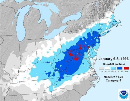
 No, that’s not a forecast map. It depicts snowfall totals from the three-day blizzard that ended 25 years ago today, in 1996. The northeaster is one of only two storms to be classified as “extreme” on the Northeast Snowfall Impact Scale,” a measure of intensity. Who remembers that whopper?
By contrast, the coming weekend will be “tranquil (some would say boring,” with “plenty of sunshine and near-normal temps,” according to a tweet Friday by the National Weather Service‘s Mount Holly office. Check out the extended forecast below. (PNWS visual. Click to enlarge.)
Friday
Mostly sunny, with a high near 40. Northwest wind 5 to 10 mph.
Friday Night
Partly cloudy, with a low around 27. North wind 5 to 15 mph.
Saturday
Mostly sunny, with a high near 38. North wind 10 to 15 mph.
Saturday Night
Partly cloudy, with a low around 25. North wind 5 to 10 mph.
Sunday
Sunny, with a high near 40. Northwest wind around 5 mph.
Sunday Night
Mostly clear, with a low around 24.
Monday
Mostly sunny, with a high near 41.
Monday Night
Partly cloudy, with a low around 28.
Tuesday
A chance of rain after 1pm. Mostly sunny, with a high near 41. Chance of precipitation is 30%.
Tuesday Night
A chance of snow before 7pm. Partly cloudy, with a low around 27. Chance of precipitation is 30%.
Wednesday
Mostly sunny, with a high near 41.
Wednesday Night
Partly cloudy, with a low around 29.
Thursday
Mostly sunny, with a high near 43.