 The remnants of Hurricane Florence, which devastated much of North Carolina over the weekend, are expected to bring heavy rain to the region that includes the Greater Red Bank Green on Tuesday, according to the National Weather Service.
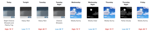
But first, the week gets off to a cloudy start. Check out the extended forecast below. (NOAA graphic. Click to enlarge.)
Monday
A slight chance of showers after 11am. Patchy fog before 9am. Otherwise, mostly cloudy, with a high near 79. Calm wind becoming southeast 5 to 9 mph in the morning. Chance of precipitation is 20%.
Monday Night
A slight chance of showers, then a chance of showers and thunderstorms after 1am. Some of the storms could produce heavy rain. Cloudy, with a low around 71. South wind 7 to 10 mph. Chance of precipitation is 40%. New rainfall amounts of less than a tenth of an inch, except higher amounts possible in thunderstorms.
Tuesday
Showers and possibly a thunderstorm. Some of the storms could produce heavy rain. High near 80. Southwest wind 10 to 15 mph. Chance of precipitation is 80%. New rainfall amounts between a half and three quarters of an inch possible.
Tuesday Night
A chance of showers before 2am. Cloudy, then gradually becoming partly cloudy, with a low around 68. West wind 6 to 10 mph becoming north in the evening. Chance of precipitation is 50%. New precipitation amounts between a quarter and half of an inch possible.
Wednesday
Mostly sunny, with a high near 75. North wind 6 to 8 mph.
Wednesday Night
Mostly clear, with a low around 64.
Thursday
Mostly sunny, with a high near 72.
Thursday Night
Partly cloudy, with a low around 64.
Friday
Mostly sunny, with a high near 80.
Friday Night
A chance of showers after 8pm. Partly cloudy, with a low around 66. Chance of precipitation is 30%.
Saturday
Mostly sunny, with a high near 76.
Saturday Night
Partly cloudy, with a low around 62.
Sunday
Partly sunny, with a high near 74.