 An excessive heat warning is in effect from noon Friday through Sunday, when heat-index values are expected to reach dangerous levels, according to the National Weather Service.
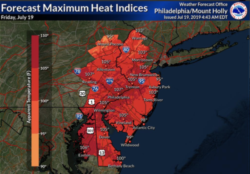
Though the Greater Red Bank Green will be cooler relative to nearby areas, “feels-like” combinations of air temperature and humidity are expected to exceed 100 degrees Friday, and could reach 110 Saturday, the NWS forecasts.
Red Bank’s Office of Emergency Management is monitoring the situation and “taking necessary precautions to prepare and respond,” according to an announcement on the borough website. Fair Haven’s OEM plans to open Bicentennial Hall, on Cedar Avenue, as a cooling station for residents who need relief, from noon Friday until 8 a.m. Monday.
Check out the extended forecast, as well as some tips on keeping cool and safe, below.
Friday
Mostly sunny, with a high near 92. Heat index values as high as 101. Calm wind becoming southwest 5 to 9 mph in the afternoon.
Friday night
Partly cloudy, with a low around 78. Southwest wind around 9 mph.
Saturday
Mostly sunny and hot, with a high near 97. Heat index values as high as 107. Southwest wind around 8 mph.
Saturday night
Partly cloudy, with a low around 79. West wind around 8 mph.
Sunday
A chance of showers and thunderstorms after 2pm. Mostly sunny and hot, with a high near 97. Southwest wind 6 to 8 mph. Chance of precipitation is 30%.
Sunday night
A chance of showers and thunderstorms. Mostly cloudy, with a low around 77. Chance of precipitation is 50%. New rainfall amounts of less than a tenth of an inch, except higher amounts possible in thunderstorms.
Monday
A chance of showers and thunderstorms, then showers likely and possibly a thunderstorm after 2pm. Partly sunny, with a high near 86. Chance of precipitation is 60%.
Monday night
Showers likely and possibly a thunderstorm before 8pm, then a chance of showers and thunderstorms after 8pm. Mostly cloudy, with a low around 70. Chance of precipitation is 60%.
Tuesday
Partly sunny, with a high near 82.
Tuesday night
Mostly cloudy, with a low around 68.
Wednesday
Mostly sunny, with a high near 82.
Wednesday night
Partly cloudy, with a low around 69.
Thursday
Mostly sunny, with a high near 84.
From to the NWS:
The excessive heat and humidity may cause heat stress or heat stroke. The most susceptible individuals are the elderly and those with pre-existing health issues.
PRECAUTIONARY/PREPAREDNESS ACTIONS:
Take extra precautions if you work or spend time outside. When
possible, reschedule strenuous activities to the early morning or
the late evening. Know the signs and symptoms of heat exhaustion
and heat stroke. Wear light weight and loose fitting clothing.
Drink plenty of water.
To reduce your risk during outdoor work, the Occupational Safety
and Health Administration recommends scheduling frequent rest
breaks in a shaded or air conditioned environment. Anyone overcome
by heat should be moved to a cool shaded location. Heat stroke is
an emergency, call 911.
An Excessive Heat Warning means that a prolonged period of
dangerously hot temperatures will occur. The combination of hot
temperatures and high humidity will create a DANGEROUS SITUATION.
Stay in an air-conditioned environment, stay out of the sun, and
check on elderly relatives and neighbors.
Young children and pets should never be left unattended in a
vehicle under any circumstance. This is especially true during hot
weather when a car’s interior can reach lethal temperatures in a
matter of minutes.