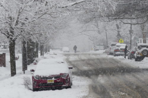
 Visibility was limited along Drs. James Parker Boulevard in Red Bank Sunday, when the second snowfall within a week dropped about eight more inches on the town.
At right, a bundled-up shoveler at work on Herbert Street while, below, one in a t-shirt cleared a sidewalk on Branch Avenue.
There’s a likelihood the Greater Green will see yet more snow this week, according to the National Weather Service. Check out the extended forecast below. (Photos by John T. Ward. Click to enlarge.)
 Monday
Sunny, with a high near 29. Northwest wind 5 to 15 mph.
Monday Night
A chance of snow, mainly after 5am. Increasing clouds, with a low around 23. Southwest wind around 5 mph becoming calm in the evening. Chance of precipitation is 30%. New snow accumulation of less than a half inch possible.
Tuesday
Snow likely before 9am, then rain and snow likely between 9am and 10am, then rain likely after 10am. Cloudy, with a high near 37. South wind around 5 mph becoming west in the afternoon. Chance of precipitation is 60%. New snow accumulation of less than a half inch possible.
Tuesday Night
Mostly cloudy, with a low around 25. Northwest wind 5 to 10 mph.
Wednesday
Partly sunny, with a high near 33. North wind 5 to 10 mph.
Wednesday Night
A chance of snow. Cloudy, with a low around 25. Chance of precipitation is 50%.
Thursday
Snow likely, mainly after 1pm. Cloudy, with a high near 32. Chance of precipitation is 60%.
Thursday Night
Snow likely. Cloudy, with a low around 25. Chance of precipitation is 60%.
Friday
A chance of snow. Mostly cloudy, with a high near 31. Chance of precipitation is 40%.
Friday Night
Mostly cloudy, with a low around 21.
Saturday
Mostly cloudy, with a high near 30.
Saturday Night
A chance of snow. Mostly cloudy, with a low around 21. Chance of precipitation is 30%.
Sunday
Partly sunny, with a high near 30.
If you value the news coverage provided by redbankgreen, please become a paying member. Click here for details about our new, free newsletter and membership information.