 Whether the Greater Red Bank Green gets any significant snowfall over the coming weekend, it’s part of a region that may be in for a “flash freeze” Sunday.
From an NJ.com report, posted Wednesday evening:
Regardless of what type of precipitation falls from the sky on Saturday night and Sunday, forecasters say the Garden State could face a dangerous ice storm as a blast of frigid Arctic air sweeps down from Canada, causing wet surfaces to rapidly freeze Sunday night.
The quick freezing, known as a flash freeze, is likely to occur because air temperatures are expected to drop as much as 20 to 30 degrees in a matter of hours, forecasters say.
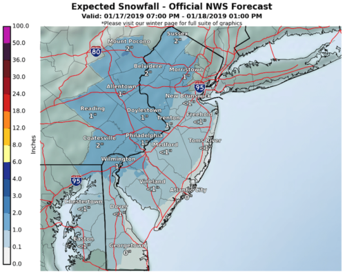
Temperatures in the Red Bank area are expected to plummet from about 41 degrees to 11 by the end of the day Sunday, making for a frigid Martin Luther King Jr. holiday the next day, according to the National Weather Service.
But before we get to that: what’s the near-term outlook? Check it out below.
Thursday
Increasing clouds, with a high near 32. North wind 5 to 8 mph becoming east in the afternoon.
Thursday night
Rain and snow before 3am, then snow between 3am and 5am, then rain and snow likely after 5am. Low around 30. Southeast wind around 5 mph becoming calm after midnight. Chance of precipitation is 80%. New snow accumulation of less than a half inch possible.
Friday
A chance of rain and snow before 8am, then a slight chance of rain between 8am and 10am. Cloudy, then gradually becoming mostly sunny, with a high near 42. Calm wind becoming west 5 to 7 mph in the afternoon. Chance of precipitation is 30%. New snow accumulation of less than a half inch possible.
Friday night
Partly cloudy, with a low around 30. West wind around 9 mph.
Saturday
Rain and snow likely after 1pm. Mostly sunny, with a high near 36. North wind 7 to 13 mph becoming east in the afternoon. Chance of precipitation is 70%. New snow accumulation of less than a half inch possible.
Saturday night
Rain and snow, becoming all rain after 8pm. Low around 35. Chance of precipitation is 90%. New precipitation amounts between 1 and 2 inches possible.
Sunday
Rain before 2pm, then rain and snow between 2pm and 4pm, then snow after 4pm. High near 41. Breezy. Chance of precipitation is 90%.
Sunday night
Mostly cloudy, with a low around 11. Blustery.
Martin Luther King Jr. Day
Mostly sunny, with a high near 16. Blustery.
Monday night
Mostly clear, with a low around 13.
Tuesday
Mostly sunny, with a high near 30.
Tuesday night
Mostly cloudy, with a low around 30.
Wednesday
A chance of showers. Mostly cloudy, with a high near 39. Chance of precipitation is 30%.