


 After causing devastation in the Bahamas, Hurricane Dorian was lashing the Carolinas Friday morning and expected to track “well offshore” of the New Jersey coast as it heads northeast toward New England and Canada, according to the National Weather Service.
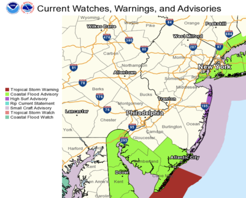
For the Greater Red Bank Green, that means gusty winds, high surf and rip tides along the Atlantic coast, but otherwise no adverse impact. In fact, the forecast shows that after a day of scattered showers Friday, the region will see lots of sun over the weekend.
Check out the extended forecast below. (NOAA graphic. Click to enlarge.)Friday
Scattered showers, mainly after 10am. Cloudy, with a high near 71. Breezy, with a northeast wind 14 to 21 mph, with gusts as high as 36 mph. Chance of precipitation is 50%. New precipitation amounts between a tenth and quarter of an inch possible.
Friday Night
Scattered showers, mainly before 5am. Cloudy, with a low around 61. Breezy, with a north wind 18 to 21 mph, with gusts as high as 31 mph. Chance of precipitation is 40%. New precipitation amounts of less than a tenth of an inch possible.
Saturday
Mostly sunny, with a high near 77. North wind 10 to 15 mph.
Saturday Night
Partly cloudy, with a low around 61. Northwest wind around 9 mph.
Sunday
Sunny, with a high near 76. Northwest wind around 8 mph.
Sunday Night
Partly cloudy, with a low around 60.
Monday
Partly sunny, with a high near 71.
Monday Night
Partly cloudy, with a low around 61.
Tuesday
Mostly sunny, with a high near 74.
Tuesday Night
Partly cloudy, with a low around 64.
Wednesday
Partly sunny, with a high near 78.
Wednesday Night
A chance of showers and thunderstorms. Mostly cloudy, with a low around 65. Chance of precipitation is 40%.
Thursday
A chance of showers and thunderstorms. Partly sunny, with a high near 77. Chance of precipitation is 40%.


