


![]() Heavy rains and gusty winds are expected to bring hazardous conditions to the Greater Red Bank Green over 24 hours starting Sunday afternoon.
Heavy rains and gusty winds are expected to bring hazardous conditions to the Greater Red Bank Green over 24 hours starting Sunday afternoon.
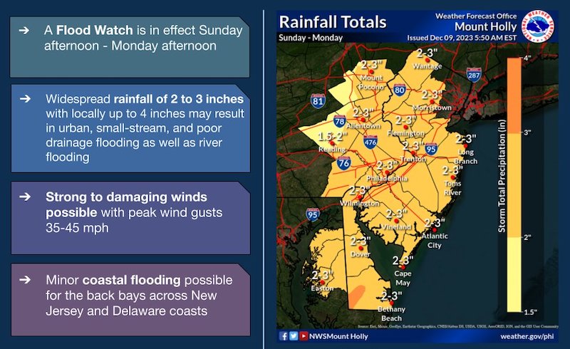
The National Weather Service is forecasting thunderstorms and winds up to 45 miles per hour to drop between two and three inches of rain across New Jersey, with some localities getting up to four inches.
The agency has a flood watch in effect through Monday afternoon.
Here’s the outlook for the coming week:
Saturday Night
Patchy fog between 8pm and midnight. Otherwise, mostly cloudy, with a low around 44. South wind 5 to 10 mph.
Sunday
Rain, with thunderstorms also possible after 10am. Some of the storms could produce heavy rain. High near 61. Breezy, with a south wind 10 to 15 mph increasing to 20 to 25 mph in the afternoon. Chance of precipitation is 100%. New rainfall amounts between a half and three quarters of an inch possible.
Sunday Night
Rain and possibly a thunderstorm. Some of the storms could produce heavy rain. Low around 38. Breezy, with a south wind 20 to 25 mph becoming northwest after midnight. Winds could gust as high as 35 mph. Chance of precipitation is 100%. New rainfall amounts between 1 and 2 inches possible.
Monday
A chance of rain before 1pm. Mostly sunny, with a high near 46. Breezy, with a west wind 20 to 25 mph, with gusts as high as 35 mph. Chance of precipitation is 50%. New precipitation amounts between a tenth and quarter of an inch possible.
Monday Night
Mostly clear, with a low around 29. Breezy.
Tuesday
Sunny, with a high near 44.
Tuesday Night
Mostly clear, with a low around 32.
Wednesday
Sunny, with a high near 44.
Wednesday Night
Mostly clear, with a low around 27.
Thursday
Sunny, with a high near 44.
Thursday Night
Mostly clear, with a low around 30.
Friday
Sunny, with a high near 48.
If you value the news coverage provided by redbankgreen, please become a financial supporter for as little as $1 per month. Click here to set your own level of monthly or annual contribution.


