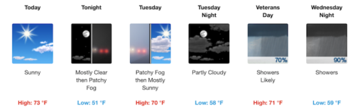
RED BANK: TORNADO THREAT AMID OUTAGES
With Tropical Storm Isais moving north through New Jersey, a man on a scooter got caught in a downpour on White Street in downtown Red Bank Tuesday morning.
Amid a growing number of power outages, the National Weather Service issued a tornado watch for 13 of the state’s counties, including Monmouth. Read More
RED BANK: ISAIAS MAY SPARE AREA ITS WORST
With about a quarter-inch of rain falling, the Greater Red Bank Green saw only a hint of Tropical Storm Isaias Monday night, according to the National Weather Service. Few JCP&L customers were without power Tuesday morning.
The region may be further spared the drenching worst of the storm Tuesday, according to NWS forecasts, though dangerous winds are still expected.
RED BANK: TROPICAL STORM WARNING ISSUED
Tropical Storm Isaias could bring heavy rain and dangerous winds to the Greater Red Bank Green Tuesday, according to the National Weather Service.
Tracking north along the Atlantic coast early Monday, the storm was expected to bring flash flooding, rip currents and possible wind gusts of 60 to 70 miles per hour, the agency said in a tropical storm warning update early Monday.
Meantime, sunshine is expected in the region Monday. Check out the extended forecast below. (NWS image. Click to enlarge.)
RED BANK: RAIN & SUN IN WEEKEND OUTLOOK
The optimism touted on a sign outside a house on Branch Avenue in Little Silver may come in handy this weekend.
According to the National Weather Service, the Greater Red Bank Green may see some showers and thunderstorms Friday and Sunday. But Saturday is forecast to be mostly sunny.
Here’s the extended outlook.
ON THE GREEN: AMPLE SUNSHINE IN FORECAST
Young paddlers on Little Silver Creek under blue skies Thursday, when temperatures peaked in the mid-70s.
Following possible scattered showers Friday, the weekend forecast includes ample sunshine Saturday and Sunday, with highs in the high 80s and low 90s, according to the National Weather Service.
Check out the extended outlook below. (redbankgreen photo. Click to enlarge.) Read More
RED BANK: SUNSHINE AND STORMS FORECAST
Sunlight danced on the Navesink River, as seen from Marine Park in Red Bank Sunday afternoon, capping a summery Fourth of July holiday weekend.
The workweek gets underway Monday with more sunshine, and temperatures in the low 90s, but followed by possible thunderstorms in the evening, according to the National Weather Service. Check out the extended forecast below. (Photo by John T. Ward. Click to enlarge.) Read More
RED BANK: FOG, SUN, RAIN & BAGPIPES
Though the outlook for performances remains hazy in the lingering pandemic, members of the Pipes and Drums of the Atlantic Watch met under foggy conditions in the parking lot of the Red Bank Middle School to rehearse Thursday evening, generating a sound that cut through the mist.
The Greater Green heads into the weekend with a dense fog advisory in effect until 10 a.m. Friday, according to the National Weather Service. And for the rest of the weekend – which includes the official start of summer, at 5:44 p.m. Saturday – expect a spotty mix of partial sunshine and threats of thunderstorms.
Check out the extended forecast below. (Video by John T. Ward. Click to enlarge.)
RED BANK: HAIL THE RETURN OF SUNSHINE
A brief hailstorm pelted the Greater Red Bank Green early Monday afternoon.
Abundant sunshine returns Tuesday for a three-day visit, according to the National Weather Service. Check out the extended forecast below. (Video by John T. Ward. Click to enlarge.) Read More
RED BANK: THE STORY, WEATHERWISE
With temperatures rising to the mid-70s, masked visitors to newly reopened Riverside Gardens Park in Red Bank strolled the public library’s Story Walk Sunday.
The story for Monday, weatherwise: partly sunny and not as warm, according to the National Weather Service. A good day, perhaps, to read the latest Story Walk installation: ‘The Sun Shines Everywhere,’ by Mary Ann Hoberman.
Check out the extended forecast below. (Photo by John T. Ward. Click to enlarge.)
ON THE GREEN: WEEKEND WEATHER OUTLOOK
Peak spring colors filled the branches and lined the side of Fair Haven Road in Fair Haven Thursday.
May, 2020 begins Friday with wet, cool conditions before giving way to sunshine and temperatures approaching 70 degrees, according to the National Weather Service. Check out the extended forecast below. (Click to enlarge.)
FAIR HAVEN: WEEKEND GOOD AND WET
Two fisherman enjoyed some socially distant relaxation on the Navesink River off Grange Avenue in Fair Haven Thursday morning. One, at right, quickly returned a fish he’d caught to the water.
The weather outlook for the Greater Red Bank Green is favorable, if you like it wet. Expect rain Friday and Sunday, though we should catch some sun Saturday, according to the National Weather Service.
Check out the extended forecast below. (Photos by John T. Ward. Click to enlarge.)
RED BANK: LEAF-BLOWING STORM FORECAST
A man working a leaf blower had Cedar Avenue in Fair Haven all to himself Sunday evening.
Nature plans to provide its own leaf blower Monday, with heavy rain and wind gusts up to 65 mile per hour possible, according to the National Weather Service. “Isolated tornadoes are also possible,” NWS warns.
Check out the extended forecast below. (Photo by John T. Ward. Click to enlarge.) Read More
RED BANK: MIXED BAG FOR HOLIDAY WEEKEND
Packages full of Easter and Passover treats awaited customer pickup at the Red Bank Chocolate Shoppe on White Street Wednesday evening.
The holiday weekend will deliver a mixed bag, starting with gusty, cool conditions Friday and bringing warm sunshine Sunday, according to the National Weather Service. Check out the extended forecast below. (Photo by John T. Ward. Click to enlarge.)
RED BANK: SOCIALLY DISTANT LAX PRACTICE
Red Bank Catholic High boys’ lacrosse players, unable to get together to practice, demonstrate an upbeat way to stay connected.
Another week in the COVID-19 era begins Monday with some cheery spring weather, even if social distances still must be observed. Check out the extended National Weather Service forecast below.(Video courtesy of RBC lacrosse. Click to enlarge.)
ON THE GREEN: SPRING ARRIVES EARLY
With spring in the air, a couple took a stroll down Markham Place in Little Silver Sunday.
The vernal equinox occured at 11:50 p.m. Thursday, marking the earliest start to spring in 124 years, according to the Farmer’s Almanac. And it debuts with summer-like conditions on the Greater Red Bank Green Friday, with temperatures peaking near 76 degrees, according to the National Weather Service.
Check out the extended forecast below. (Click to enlarge.) Read More
RED BANK: ICE IN NEAR-TERM FORECAST
The surest sign of spring’s approach on the Greater Green may be the annual reopening of Strollo’s Lighthouse Italian Ice in Red Bank. And that’s scheduled to happen at noon Friday.
Meantime, the winter of 2020 continues to serve up unseasonably warm days, according to the National Weather Service. Check out the extended forecast below. (Photo by Trish Russoniello. Click to enlarge.)
RED BANK: WINTER MARCHES TOWARD SPRING
A thin layer of ice – an infrequent sight this unseasonably warm and almost snowless winter – covered a puddle in Marine Park in Red Bank Saturday morning.
The first work week of March will bring more springlike conditions, with sunshine and a peak temperature in the high 50s Monday, according to the National Weather Service.
Check out the extended forecast below. (Photo by John T. Ward. Click to enlarge.)
RED BANK: FORECAST HAS SPRING IN ITS STEP
Impatiens on West Front Street in Red Bank seemed to signal an early spring last week.
This week’s weather on the Greater Red Bank Green will indeed be more springlike than wintry, with warmish temperatures and drizzles in the forecast, according to the National Weather Service. Check it out below. (Photo by Trish Russoniello. Click to enlarge.)
RED BANK: WARM, SUNNY WASHINGTON’S DAY
The workweek that inaugurates Monday with Washington’s Birthday starts off sunny and warm but will end much colder, according to the National Weather Service.
Check out the extended forecast below. (Weather.gov image. Click to enlarge.) Read More
RED BANK: WEEKEND WEATHER NOT TOO FOUL
A seagulls and waterfowl made the most of foul weather on the Navesink River off Red Bank Thursday.
Beginning Friday, the Greater Red Bank Green is in for a string of partly-to-mostly sunny days through Monday, Washington’s Birthday. Peak daytime temperatures Friday and Saturday will be colder than we’ve seen recently, but rise Sunday and Monday, according to the National Weather Service.
Check out the extended forecast below. (Photo by John T. Ward. Click to enlarge.) Read More
RED BANK: DAMP START TO WORKWEEK
Little Silver Creek at the foot of Prospect Avenue in Little Silver mirrored a painterly sky Sunday afternoon.
Another workweek begins on a damp note, with a high chance of rain Monday and Tuesday, according to the National Weather Service. Check out the extended forecast for the Greater Red Bank Green below. (Photo by Trish Russoniello. Click to enlarge.)
RED BANK: DREARY, DAMP, AND NOW, WINDY
A pair of deer seen wandering Locust Avenue in Red Bank near the Bellhaven wetlands Thursday afternoon.
A string of wet, dreary days continued with heavy fog Friday morning, along with a National Weather Service warning of possible strong winds through 7 p.m., with gusts up to 60 miles per hour. Sunshine was expected to return Saturday.
Check out the extended forecast below. (Photo by John T. Ward. Click to enlarge.)
RED BANK: GROUNDHOGS SEE EARLY SPRING
Punxsutawney Phil may not have the best track record as a forecaster. But he did not see his shadow Sunday, which tradition says is indicative of an early spring.
Closer to the Greater Red Bank Green, Milltown Mel, using an identical forecasting model, came to the same conclusion.
Meantime, the workweek gets off to a spring-ish start Monday, with plenty of sunshine and temperatures peaking in the high 50s, according to the National Weather Service.
Check out the extended forecast below. (Visual by Trish Russoniello. Click to enlarge.)
RED BANK: WEEKEND WEATHER OUTLOOK
A tweet from the National Weather Service‘s regional operation in Mount Holly early Friday morning.
What’s to hate? OK, so the outlook for the Greater Red Bank Green includes cloudy skies Friday and Saturday. But sunshine returns for Super Bowl Sunday, and peak temperatures hover in the mid-40s throughout. Could be worse.
Check out the extended forecast below. (Photo by John T. Ward. Click to enlarge.)